


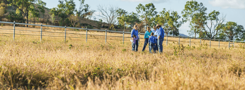
Land Management Plans|Fitzroy Region – What it means? and Why is it important.
Posted on April 1st, 2024
What is the meaning of Land Management ?
Land management refers to the strategic process by which land is utlised and maintained to achieve specific land use outcomes. Land management encompasses various practices and techniques aimed at optimising land resources, ensuring sustainability and balancing both the environmental, economic and
Land management refers to the strategic process by which land is utlised and maintained to achieve specific land use outcomes. Land management encompasses various practices and techniques aimed at optimising land resources, ensuring sustainability and balancing both the environmental, economic and social needs.
Effective land management requires collaboration and coordination among its various land management stakeholders, this can include but is not limited to government agencies, private landowners, indigenous communities, conservation organisations and local communities.
Land management is broken into; land management planning, land management administration and the execution of land management strategies.
Successful land management allows individuals and organisations to make informed decisions regarding the use of land for purposes such as agriculture, conservation, urban development or recreation. All while considering the long-term impact on the ecosystem and local communities.
How Can A Land Management Plan Help Me?
As a land manager, your livelihood depends on your ability to manage your business in a way that maximises profit while aligning with your goals and being sustainable into the future.
This rule of thumb highlights the importance of looking at the bigger picture and putting a plan in place that will guide your land management plan in the Fitzroy Region and highlight practices that allow you to track the results of changes you implement.
Embracing the opportunity – A GRASS project

Land Management Plans | Fitzroy Region
Identifying and writing down short, medium, and long-term business goals can help identify whether everyone involved in the business is on the same (or at least similar) pages. This process can take some time to bed down and should not be rushed. Remember that for goal setting to be effective, goals need to be SMART.
S – SPECIFIC and clear otherwise you won’t be able to focus your efforts or feel truly motivated.
M – MEASURABLE so you can track your progress and stay motivated.
A – ATTAINABLE and realistic. Goals should stretch your abilities but remain possible.
R – RELEVANT and worthwhile and something that will impact your business.
T – TIME BOUND so you have a deadline or target date to work towards.
When breaking down goals its best to use the following time frames. Short term (1-2 years) Medium term (3 – 5 years) and Long term (6-10 years)
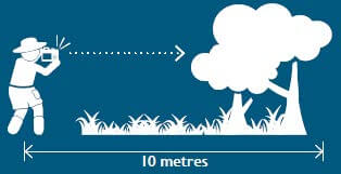
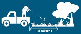
Monitoring sites are a great way of tracking progress and changes over time. Without documented records such as photo monitoring sites, it is very difficult to recall what a particular paddock, gully or land in poor condition looked like the year before. There are a few key guidelines when it comes to setting up photo monitoring sites.
Selecting a monitoring site
Inspect the whole paddock: get a feel for the area, the characteristics of the representative land type and the areas of concern- Plot sites randomly but more than…
- 300m away from stockyards, watering points, homesteads, drains, sheds, gas/oil wells, lick points, and water bodies
- 100m away from a gate
- 25m away from a fence, road, track, powerline, railway, pipeline, closed track, road or old fence line
Taking monitoring photos
A comprehensive property map is a vital tool when planning and managing your grazing. A property map can come in many different forms such as a hand-drawn, paper version, a static electronic version saved on your computer or printed out, or an online map created using a specific mapping program that can be easily updated. Whatever type of property map you choose to use, there are a few key elements your map needs to have to be a useful planning tool. Learn more about property mapping.
Elements to Include on Your Property Map
- Property boundary – also known as cadastre, lot on plan or land parcel
- Paddocks/fences – including accurate paddock sizes
- Water points (i.e., where cattle drink) – TIP: it is good to identify between different types of watering points (e.g., dam, trough, creek, river)
- Water sources – bore, tank, dam, river etc
- Pipelines – TIP: it is good to identify different size pipelines and where taps, pumps and telemetry are located
- Infrastructure – such as cattle yards, sheds, houses etc.
- Roads/tracks/fire breaks
Other elements that may be useful to include on your property map:
- Walk-to-water circles
- Weed infestations
- Emergency assembly points
- Chemical storage locations
- Problem areas e.g., gullies, scalding, erosion
Useful Resources
Why are the Reef Protection Regulations required?
The Reef protection regulations address land-based sources of water pollution flowing to the Great Barrier Reef. Over time, unsustainable grazing practices reduce pasture and ground cover which increases the risk of valuable topsoil being lost when it rains. The regulations for grazing, focus on retaining and improving ground cover and land condition to minimise soil loss and is assessed at 30th of September each calendar year.
What are the requirements for grazing?
There are four standard conditions that need to be met:
- For land in good or fair condition (greater than 50% ground cover), continue to use measures to maintain the land in good or fair condition.
- For land in poor condition (less than 50% ground cover), measures must be implemented to improve land condition towards achieving good or fair condition.
- For land in degraded condition (less than 20% ground cover), measures must be implemented to improve land condition towards achieving good or fair condition OR preventing areas of degraded land condition from further degrading or expanding.
- Keep records of property and person details, chemical and fertiliser products applied and measures implemented to improve land condition.
What can you do?
Where land is in poor or degraded condition, the following are examples of measures that may be used to improve land condition:
- Adjusting grazing pressure/stocking rate to match land condition
- A planned program of wet season spelling of land to improve land condition;
- Managing preferential grazing, through actions such as:
- Additional fencing,
- Establishing additional/relocating watering points,
- Strategic placement of licks;
- Managing and reduce gullies and early signs of gullying;
- Managing linear infrastructure to minimise erosion;
- Establishing diversion banks;
- Sowing pastures;
- Managing weeds;
- Any other measure that improves land condition or prevents areas of degraded land condition from further degrading or expanding.
Useful Resources
To start on your own Land Management plan in the Fitzroy Region Contact Us
What are the functions of Land Management?
When it comes to land management there are several key functions that need to be ensured to help maintain sustainable use of the land while continuing to balance the economical, environmental and social needs. Below we look at each of the functions and provide a brief explanation.
- Resource Allocation and Planning: Land management involves determining the most appropriate use of land based on its characteristics and potential. This includes urban planning, agricultural development, conservation efforts, and infrastructure projects.
- Sustainability and Environmental Protection: Effective land management ensures the protection of ecosystems and natural resources, promoting practices that minimize environmental degradation, soil erosion, deforestation, and loss of biodiversity. This often involves setting aside land for conservation or encouraging sustainable farming techniques.
- Land Use Regulation: Land management includes enforcing policies, zoning laws, and regulations that dictate how land can be used. This is crucial in balancing competing interests, such as development versus conservation, while ensuring legal compliance.
- Economic Development: Land management plays a key role in facilitating economic growth by designating areas for commercial, industrial, and residential development. Properly managed land can attract investment, increase property values, and create jobs.
- Cultural and Heritage Preservation: In certain areas, land management also involves protecting sites of historical or cultural significance. This ensures that land with cultural heritage value is preserved for future generations and respected during development.
- Community Involvement and Social Equity: Effective land management seeks to involve local communities in decision-making processes to ensure that land use benefits a wide range of stakeholders. This includes equitable access to resources, public spaces, and housing.
- Mitigating Natural Disasters: Land management strategies can help mitigate the risks of natural disasters such as floods, landslides, and droughts by ensuring that land is used in ways that reduce vulnerability, such as by protecting wetlands, forests, and natural drainage systems.
- Infrastructure and Utility Management: Land management ensures that essential infrastructure, such as roads, utilities, and public facilities, is developed in a manner that serves the community efficiently and sustainably.
- Monitoring and Adaptation: A key function of land management is to monitor the effects of land use and adapt strategies to changing environmental, social, or economic conditions. This helps ensure the long-term viability of the land.
These functions are interconnected, with the goal of achieving a balance between development, conservation, and social welfare.
Learn more about how Land Management in the Fitzroy Region can help you
FBA has many resources that can help you get started on your own land management journey, take a look at some of the land owners we have helped with over the years.